Rendered at 17:42:11 11/13/24
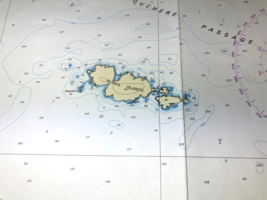
QUEEN CHARLOTTE STRAIT Nautical Chart VANCOUVER ISLAND Map 46"x33" BC Canada
$24.74
Shipping options
$10.00 to United States
Offer policy
OBO - Seller accepts offers on this item.
Details
Return policy
Purchase protection
Payment options
PayPal accepted
PayPal Credit accepted
Venmo accepted
PayPal, MasterCard, Visa, Discover, and American Express accepted
Maestro accepted
Amazon Pay accepted
Item traits
| Category: | |
|---|---|
| Quantity Available: |
Only one in stock, order soon |
| Condition: |
Used |
| Country/Region of Origin: |
Canada |
| Original/Reproduction: |
Vintage Original |
| Military Branch: |
None |
| Time Period, War: |
2004 |
| Stuart Narrows, Inside Passage: |
Kenneth Passage, Broughton Island |
| Chart: |
3547 |
Listing details
| Shipping discount: |
No combined shipping offered |
|---|---|
| Posted for sale: |
More than a week ago |
| Item number: |
1665046155 |
Item description
Added to your wish list!

- QUEEN CHARLOTTE STRAIT Nautical Chart VANCOUVER ISLAND Map 46"x33" BC Canada
- 1 in stock
- Price negotiable
Get an item reminder
We'll email you a link to your item now and follow up with a single reminder (if you'd like one). That's it! No spam, no hassle.
Already have an account?
Log in and add this item to your wish list.


