HISTORIX Vintage 1879 Minneapolis Map Poster - 26x38 Inch Black Framed Vintage M
Shipping options
Seller handling time is 2 business days Details
This reflects the seller's handling time and may not include time spent in transit.
If you have questions about shipping, please contact the seller.
FREE via to United States
Return policy
Full refund available for DOAs
Details
- We guarantee our products and offer full refunds or exchange for defective items or items not as-described.
- Buyer must contact us within 30 days after receipt of shipment.
- The item must be received in the same condition as shipped.
- Items must be returned with all original packaging and accessories.
- Items must not be abused, modified or damaged by accident.
- A 20% restocking fee will be charged for returns
- Buyer is responsible for all return shipping and handling fees.
- Restocking and return shipping fees do not apply when item is returned as defective or because incorrect product was delivered.
Payment options
PayPal accepted
PayPal Credit accepted
Venmo accepted
PayPal, MasterCard, Visa, Discover, and American Express accepted
Maestro accepted
Amazon Pay accepted
Nuvei accepted
Item traits
| Category: |
Books & Magazines
|
| Quantity Available: |
8 in stock
|
| Condition: |
New
|
| ASIN: |
B09K6FQK6F
|
| EAN: |
0737214972365
|
| UPC: |
737214972365
|
| Paint Type: |
Acrylic
|
| color: |
Black Frame
|
| Externally Assigned Product Identifier: |
0737214972365
|
| Item Shape: |
Rectangular
|
| Bullet Point: |
View details
VINTAGE MAP FRAMED: You’ll love this high-quality black framed historic reproduction of 1879 Minneapolis Map Poster. Our ready-to-hang maps are printed and framed in the USA by professional art framers using the highest quality materials. Each ord...
|
| theme: |
City,Love,Maps,Vintage
|
| Product Description: |
View details
Published by pioneering lithographer, illustrator, and mapmaker Albert Ruger, this stunning depiction of Minneapolis in 1879, shows the city in a period of significant growth and transition. Ruger's bird's eye perspective technique wa...
|
| brand: |
HISTORIX
|
| Unspsc Code: |
55101500
|
| Special Feature: |
Lightweight
|
| orientation: |
Landscape
|
| Item Name: |
View details
HISTORIX Vintage 1879 Minneapolis Map Poster - 26x38 Inch Black Framed Vintage Minneapolis Minnesota Map Print - Old City of Minneapolis Wall Art - History Map of Minneapolis MN
|
| Item Type Keyword: |
prints
|
| Mounting Type: |
Wall Mount
|
| size: |
38L" x 26W"
|
| material: |
Plastic
|
| Wall Art Form: |
poster
|
| Target Gender: |
unisex
|
Listing details
|
Seller policies:
|
View seller policies
|
|
Shipping discount:
|
Seller pays shipping for this item.
|
|
Posted for sale:
|
More than a week ago
|
|
Item number:
|
1736382842
|
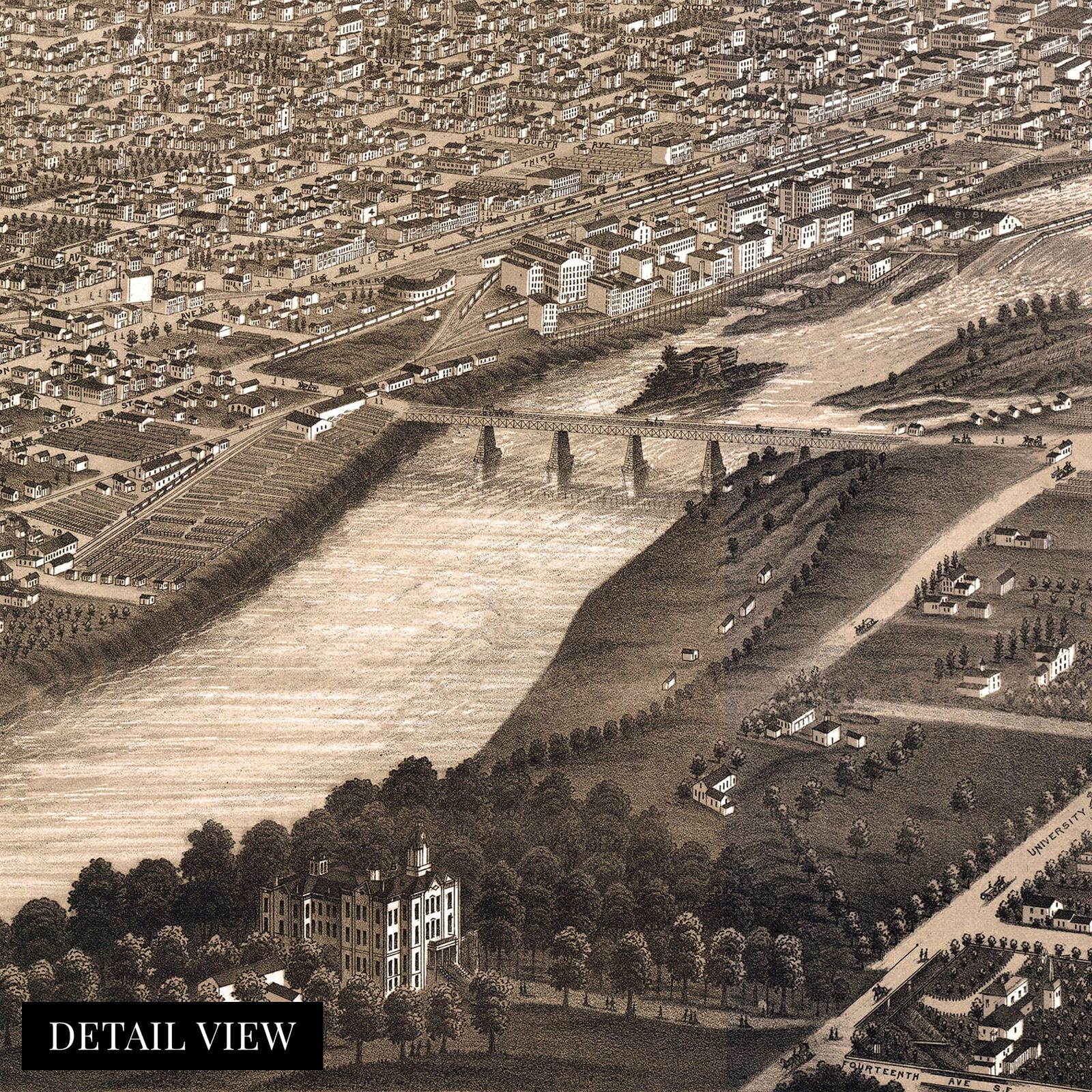
Published by pioneering lithographer, illustrator, and mapmaker Albert Ruger, this stunning depiction of Minneapolis in 1879, shows the city in a period of significant growth and transition. Ruger's bird's eye perspective technique was becoming in vogue during the middle part of the nineteenth century and was one of the most popular styles by the turn of the century. The distinctive aesthetic of these perspectives immediately transports the viewer back in time. These maps were produced not only to promote the city to prospective merchants and workers but for local businesses and residents to display their civic pride.
Minneapolis grew around Fort Snelling, which had been established at the confluence of the Mississippi and Minnesota Rivers, where the Saint Anthony Falls provided power for numerous flour and sawmills. Saint Anthony to the east was annexed by Minneapolis in 1872 to form one city that spanned the rivers banks.
European immigrants had flocked to the region during the nineteenth century due to its cold climate and vast dairy and farmlands that were reminiscent of the lands of Northern Europe and Scandinavia. These immigrants established numerous close-knit communities throughout the state. During Industrialization, many flocked to Minneapolis for jobs in manufacturing and milling, further establishing neighborhoods based on each unique heritage. By 1879 Minneapolis produced a majority of the nation's flour and relied heavily on the robust spring wheat, which was harvested in the summer. Minneapolis's rich history and unique character are on display in this authentic piece of cartographical history.
Our ready-to-hang wall art are printed and framed in the USA using the highest quality materials with professional craftsmanship. This beautiful artwork is a perfect addition to your themed decor. Historic prints look great in the home, study or office. They also make an unforgettable gift.
Additional Details
------------------------------
Bullet point: VINTAGE MAP FRAMED: You?ll love this high-quality black framed historic reproduction of 1879 Minneapolis Map Poster. Our ready-to-hang maps are printed and framed in the USA by professional art framers using the highest quality materials. Each order is inspected for quality. This beautiful artwork is a perfect addition to your themed decor. Vintage maps look great in the home, study or office. They also make an unforgettable gift.
Product description:
Published by pioneering lithographer, illustrator, and mapmaker Albert Ruger, this stunning depiction of Minneapolis in 1879, shows the city in a period of significant growth and transition. Ruger's bird's eye perspective technique was becoming in vogue during the middle part of the nineteenth century and was one of the most popular styles by the turn of the century. The distinctive aesthetic of these perspectives immediately transports the viewer back in time. These maps were produced not only to promote the city to prospective merchants and workers but for local businesses and residents to display their civic pride.
Minneapolis grew around Fort Snelling, which had been established at the confluence of the Mississippi and Minnesota Rivers, where the Saint Anthony Falls provided power for numerous flour and sawmills. Saint Anthony to the east was annexed by Minneapolis in 1872 to form one city that spanned the rivers banks.
European immigrants had flocked to the region during the nineteenth century due to its cold climate and vast dairy and farmlands that were reminiscent of the lands of Northern Europe and Scandinavia. These immigrants established numerous close-knit communities throughout the state. During Industrialization, many flocked to Minneapolis for jobs in manufacturing and milling, further establishing neighborhoods based on each unique heritage. By 1879 Minneapolis produced a majority of the nation's flour and relied heavily on the robust spring wheat, which was harvested in the summer. Minneapolis's rich history and unique character are on display in this authentic piece of cartographical history.
Our ready-to-hang wall art are printed and framed in the USA using the highest quality materials with professional craftsmanship. This beautiful artwork is a perfect addition to your themed decor. Historic prints look great in the home, study or office. They also make an unforgettable gift.