HISTORIX Vintage 1869 Urbana Champaign Illinois Map Print - 18x24 Inch Vintage B
Shipping options
Seller handling time is 2 business days Details
This reflects the seller's handling time and may not include time spent in transit.
If you have questions about shipping, please contact the seller.
FREE via to United States
Return policy
Full refund available for DOAs
Details
- We guarantee our products and offer full refunds or exchange for defective items or items not as-described.
- Buyer must contact us within 30 days after receipt of shipment.
- The item must be received in the same condition as shipped.
- Items must be returned with all original packaging and accessories.
- Items must not be abused, modified or damaged by accident.
- A 20% restocking fee will be charged for returns
- Buyer is responsible for all return shipping and handling fees.
- Restocking and return shipping fees do not apply when item is returned as defective or because incorrect product was delivered.
Payment options
PayPal accepted
PayPal Credit accepted
Venmo accepted
PayPal, MasterCard, Visa, Discover, and American Express accepted
Maestro accepted
Amazon Pay accepted
Nuvei accepted
Item traits
| Category: |
Kitchen Scales
|
| Quantity Available: |
8 in stock
|
| Condition: |
New
|
| UPC: |
705514888877
|
| MPN: |
ENMAP06561824
|
| EAN: |
0705514888877
|
| binding: |
unbound
|
| format: |
unbound
|
| language: |
english
|
| Bullet Point: |
View details
VINTAGE MAP REPRODUCTION: You’ll love this high quality historic reproduction of 1869 Urbana Champaign Illinois Map Print. Our museum quality prints are archival grade, which means it will look great and last without fading for over 100 years. Our...
|
| Product Description: |
View details
This bird's eye perspective map was produced by Prussian-born cartographer Albert Ruger under his Chicago Lithographing Company in 1869. It shows the town as it started to experience a period of growth and transformation as residents from the A...
|
| Brand: |
HISTORIX
|
| Unspsc Code: |
55101500
|
| Externally Assigned Product Identifier: |
705514888877
|
| Item Type Keyword: |
prints
|
| Part Number: |
ENMAP06561824
|
| Style: |
Classic
|
| Color: |
Natural
|
| manufacturer: |
HISTORIX
|
| Item Shape: |
Rectangular
|
| Publication Date: |
1869T
|
| Paper Finish: |
matte
|
| Map Scale: |
1000
|
| Item Name: |
View details
HISTORIX Vintage 1869 Urbana Champaign Illinois Map Print - 18x24 Inch Vintage Bird's Eye View of Urbana City Champaign Illinois Map Poster Wall Art
|
| Product Site Launch Date: |
2023-08-19T19:22:43.018Z
|
Listing details
|
Seller policies:
|
View seller policies
|
|
Shipping discount:
|
Seller pays shipping for this item.
|
|
Posted for sale:
|
More than a week ago
|
|
Item number:
|
1735807630
|
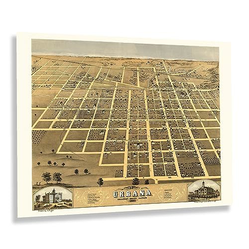
This bird's eye perspective map was produced by Prussian-born cartographer Albert Ruger under his Chicago Lithographing Company in 1869. It shows the town as it started to experience a period of growth and transformation as residents from the American South flocked to the Midwest eager for economic opportunities as manufacturing jobs became readily available during the early portions of the industrial revolution. Urbana was first settled in 1822 and was a primarily agricultural community with vast farms being established surrounding the city's incorporated boundaries. Urbana maintains a classic small-town community feel and is host to numerous summer festivals, farmers' markets, and is home to the University of Illinois, Urbana-Champaign.
Ruger's bird's eye perspectives were among some of the first of this style to be made in the United States, and he was an early pioneer of the form that would go on to inspire numerous other prolific lithographers and cartographers, including Henry Wellge, J.J. Stoner, and Beck Pauli with whom he would later collaborate. Panoramic maps have a distinctive style and unique aesthetic that is immediately recognizable and transports the viewer back in time, creating an indelible bond between the past and present.
As the nation recovered following the conclusion of the American Civil War, towns like Urbana became popular destinations, and numerous neighborhoods and communities were established based on cultural heritage, many of which exist today. This map is an authentic piece of American cartographical history that depicts a classic American small town during a period of growth.
Additional Details
------------------------------
Bullet point: VINTAGE MAP REPRODUCTION: You?ll love this high quality historic reproduction of 1869 Urbana Champaign Illinois Map Print. Our museum quality prints are archival grade, which means it will look great and last without fading for over 100 years. Our print to order maps are made in the USA and each map is inspected for quality. This beautiful artwork is a perfect addition to your themed decor. Vintage maps look great in the home, study or office. They make a perfect gift as well.
Product description:
This bird's eye perspective map was produced by Prussian-born cartographer Albert Ruger under his Chicago Lithographing Company in 1869. It shows the town as it started to experience a period of growth and transformation as residents from the American South flocked to the Midwest eager for economic opportunities as manufacturing jobs became readily available during the early portions of the industrial revolution. Urbana was first settled in 1822 and was a primarily agricultural community with vast farms being established surrounding the city's incorporated boundaries. Urbana maintains a classic small-town community feel and is host to numerous summer festivals, farmers' markets, and is home to the University of Illinois, Urbana-Champaign.
Ruger's bird's eye perspectives were among some of the first of this style to be made in the United States, and he was an early pioneer of the form that would go on to inspire numerous other prolific lithographers and cartographers, including Henry Wellge, J.J. Stoner, and Beck Pauli with whom he would later collaborate. Panoramic maps have a distinctive style and unique aesthetic that is immediately recognizable and transports the viewer back in time, creating an indelible bond between the past and present.
As the nation recovered following the conclusion of the American Civil War, towns like Urbana became popular destinations, and numerous neighborhoods and communities were established based on cultural heritage, many of which exist today. This map is an authentic piece of American cartographical history that depicts a classic American small town during a period of growth.
Format: wall_map