HISTORIX Vintage 1879 Utah State Map - 18x24 and 50 similar items
Free Shipping
HISTORIX Vintage 1879 Utah State Map - 18x24 Inch Utah State Vintage Map Wall Ar
$39.99 - $59.99
View full item details »
Shipping options
Seller handling time is 1 business day Details
FREE via to United States
Return policy
Full refund available for DOAs
Details
Purchase protection
Payment options
PayPal accepted
PayPal Credit accepted
Venmo accepted
PayPal, MasterCard, Visa, Discover, and American Express accepted
Maestro accepted
Amazon Pay accepted
Nuvei accepted
Item traits
| Category: | |
|---|---|
| Quantity Available: |
16 in stock |
| Condition: |
New |
| ASIN: |
B08JKL85SH |
| Item Name: |
HISTORIX 1879 Territory of Utah |
| manufacturer: |
HISTORIX |
| Item Type Keyword: |
prints |
| Brand: |
HISTORIX |
| Unspsc Code: |
52140000 |
| sizes: |
Listing details
| Seller policies: | |
|---|---|
| Shipping discount: |
Seller pays shipping for this item. |
| Posted for sale: |
April 13 |
| Item number: |
1738888351 |
Item description
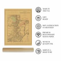
Produced by prolific American lithographer Julius Bien, this depiction of the Utah territory bears a distinctive aesthetic and a tremendous amount of detail. Bien produced a large body of work throughout the 19th century, and his works signature style immediately transports the viewer back in time. Bien is perhaps most well known for his lithography work with John Woodhouse Audubon on a color edition of his father’s iconic The Birds of America in the late 1850s.
At the time of the production of this map Utah had not achieved statehood and was still considered a territory. The rugged terrain and geologic features common throughout the region, including the Great Salt Lake, have long shaped the culture and economy of Utah. The completion of the first transcontinental rail line occurred just seven years prior to this publication. It brought numerous immigrants to the region, establishing Salt Lake City and creating a prosperous community. The rail line opened access to the American West and spurred on a boom of westward expansion.
Utah experienced economic development in mineral mining throughout the late 19th century, and mining towns sprung up throughout the western regions of the state. Utah was admitted into the Union in 1896 as the forty-fifth state, and Biel’s illustration remains an authentic piece of American cartographical history. As Utah developed through the end of the 19th-century, government maps proved vital tools for residents and merchants alike, allowing for civic planning, agricultural record maintenance, and planned railroad lines that opened access to the state.
Our museum quality giclee print comes printed with archival ink on premium heavyweight matte paper. Shipped in a sturdy cardboard tube your print will arrive ready to be framed. This eye-catching vintage map reproduction print makes the perfect gift for anyone that loves history and imagery.
|
Why are we showing these items?
Booth
Historic Prints |

|

-
Refine your browsing experience
We can show you more items that are exactly like the original item, or we can show you items that are similar in spirit. By default we show you a mix.
This item has been added to your cart
 HISTORIX Vintage 1879 Utah State Map - 18x24 Inch Utah State Vintage Map Wall Ar added to cart.
16 available in stock
View Cart or continue shopping.
 Please wait while we finish adding this item to your cart.
Get an item reminder
We'll email you a link to your item now and follow up with a single reminder (if you'd like one). That's it! No spam, no hassle.
Already have an account?
Log in and add this item to your wish list.


